Cattle tracks are routes or itineraries along which cattle have traditionally traveled. They are the roads necessary to move the herd looking for pastures (food) in the summer or winter season.
They developed in the Middle Ages with the creation of the guild and numerous privileges and rights. The decline of the wool trade together with the existing corruption caused these rights to be abolished in Cádiz (1812). The Valencian system (foral law) on livestock routes is different from the centralist model of Castile. For example, the Castilian royal canyon measures 75 m. in front of the 40 m. valencians Our municipal law also speaks of a cattle path, of grass, of cattle, assagador, godfather, pas, cordill versus the Castilian terms "cordel, colada, vereda or cañada". Also, in our system, they are, for all intents and purposes, considered cattle tracks: the rest areas, the troughs and the meshes.
For many of you, it will sound like “in Chinese”. A very distant past because, practically, there are no transhumant herds left in our counties. Even so, this heritage, these livestock routes, are part of "the green infrastructure of the CV" (law 5/2014 on planning the territory, town planning and landscape of the CV). We can and must preserve them by reusing them.
In wich way? Converting them into ecological connectors and having a recreational use for walking, hiking, etc. In addition, the elements associated with livestock routes (troughs, bridges, rest areas, etc.) are an important historical and cultural heritage. Law 3/2014, July 11, of the Generalitat, while respecting Law 3/1995, March 23, of the Central Government, regulates the livestock routes of the CV and in it tells us that they are a heritage to be preserved and although it talks about "..presunciones possessorias iuris tantum de titularidad...", it also recognizes "...dominical questions that are reserved to the civil jurisdiction".
Depending on the width of the road, there are 3 types of roads:
1.- ravines, up to 75 meters wide;
2.- mountain ranges, up to 37.5 meters;
3.- ditches/lanes up to 20 meters wide.
In the term of Albaida there are 8 routes:
– 4 mountain ranges (Alicante, Murcia, Camí d’Ontinyent to Gandia, Camí Vell de Xàtiva to Alicante),
– 4 tasting rooms (La Casa del Manco, the Camí Vell de Xàtiva, the Quatre Camins and the Camí dels Clots).

This writing is based on a project (preserved in the Municipal Archive of Albaida) of classification made in the summer of 1972 by the agricultural expert Rafael Negro Pavón. Approved and published five years later in the BOP of July 13, 1977 and in the BOE of September 2, 1977.
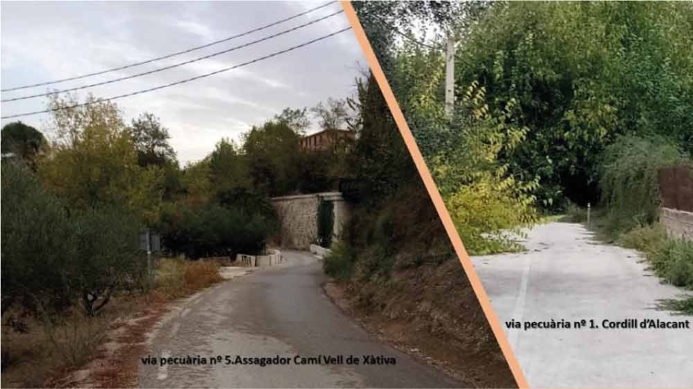
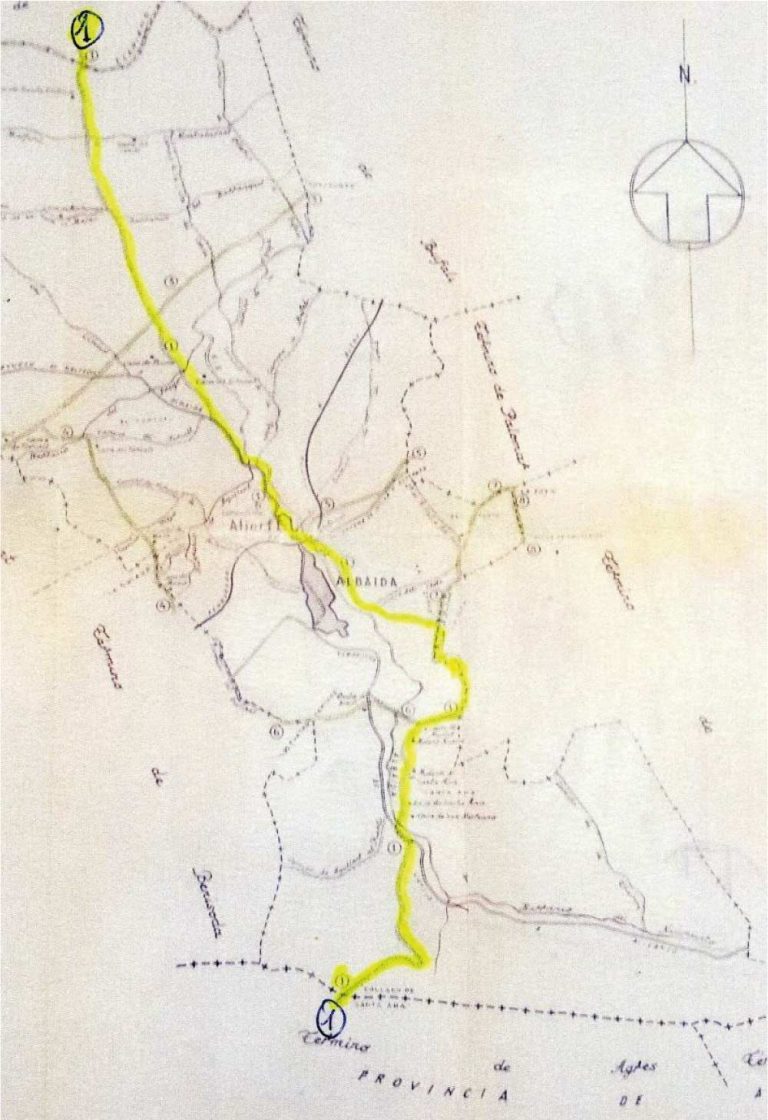
Nº 1.- Cordill of Alicante.
Its width is 37 meters and 61 centimeters. It is approximately eleven kilometers and one hundred meters long. It comes from the area of L'Olleria through the areas of Tossal and L'Arribador and crosses the Clarià river leaving Casa Sta. Clotilde and crossing the road from Aielo to Montaverner. On the left is the Barranquets ravine. Cross the ridge of Camí Vell d'Ontinyent and cross the ravine of Pregó and Agullent, leaving the Albaida river on the left and the Aljorf cemetery on the right. Cross the village, the railway from Xàtiva to Alcoi and the road from Xàtiva to Alicante. Leave on the left, the Camí dels Clots until the end of Atzeneta. Following the Atzeneta road, leave the Casa de Monzó, the Molí Nou and the Molins de Santa Anna on the left. Cross the Albaida river to go up the Camí d'Agres to the place of Colla(d)o.
Nº 2.- Cordillera de Murcia.
The width of this livestock road is 37 meters and sixty one centimeters. It is a mountain range that runs along the dividing line between the municipalities of Aielo de Malferit and Albaida. Then, only half of its width belongs to Albaida. Its length in term is five meters. Enter through the terme d'Aielo, cross the Clarià river in a southerly direction, cross the old road from Font de la Figuera – Xàtiva to the 3-terme mollón (Aielo, Agullent, Albaida). The mountain range continues through Agullent.

Nº 3.- Cordill del Camí d'Ontinyent in Gandia.
Same width (37.61 m.) with a length, more or less, of four thousand meters. It comes from the term of Agullent along the Camí Vell d'Ontinyent in Gandia with a NE direction and leaves Batiste Gil's house on the left and Forcall's house on the right. Cross the road of Aielo, the Camí del Císcar and the Camí de la casa del Comte, leaving the Barranquets on the left and the Albaida river on the right. Cross the road from L'Olleria to Bufali and continue towards Bufali through the Colltorta area.

Nº 4.- Asserator of the "Casa del Manco".
The legal width of this road is 8 meters and it has an approximate length of two thousand meters crossing the term. As with the term of Benissoda, half of the dryer corresponds to each town. As we said, enter through the term of Benissoda, leave Casa del Manc on the right, cross the ravine of Silla, leaving the place of La Solana on the left, heading NW through the term of Albaida. On the right, leave the Corralet de Mesa and cross the old road from Ontinyent to Albaida, leave the Forcall road on the right, crossing the Barranc del Pregó until you reach the Cordill d'Ontinyent in Gandia.

Nº 5.- Asesager of the Camí Vell de Xàtiva.
The legal width is 8 meters and its length by term is 1,400 meters. From Cordill d'Alacant and next to the railway from Xàtiva to Alcoi, leave the Ermita del Roser on the left, cross the train continue in a NE direction along the road from Xàtiva to Alicante, leave it on the right and enter the Palomar term.

Nº 6.- Asesager of the Four Paths.
The legal width is 8 meters and has a length of approximately 1,400 meters according to the municipal term. It comes from the district of Benissoda along the Camí de Santa Anna in an E direction. It arrives at the Quatre Camins area, crossing the district of Albaida and continues along the Camí d'Agres. Cross the road from Xàtiva to Alicante, leaving Venta de Soler on the right and reaching the Atzeneta road on the left. It crosses the Albaida river and ends in Cordill d'Alacant. In the sections that go through the terms milestone, for meter evaluation purposes, only half are from Albaida.

Nº 7.- Asesager of the Camí dels Clots.
The legal width is 8 meters and its length by the term of Albaisa is 1,200 meters. In the section that runs through the landmarks of the Atzeneta and El Palomar thermal baths, only half belongs to Albaida. From Cordill d'Alacant, enter through the areas of la Xova, on the left, and la Judà, on the right. It has a N direction following the landmark of the terms of Atzeneta and Albaida. Pass next to the Clots mill, continue past the Clots house, leaving the path from Bufali to Atzeneta on the left, continuing towards El Palomar.

Nº 8.- Cordill of the Camí Vell from Xàtiva to Alicante.
The legal width of the livestock road is 37.61 meters and the approximate length within the Albaida area is five hundred meters. As this mountain range runs between the terms of Atzeneta and Albaida, for the purposes of evaluating the meters, half for each term. Enter through the Palomar terminus and head S between the terminus of Atzeneta and Albaida, leaving the area of La Foia and l'Altet de l'Església on the left, continuing through the Atzeneta terminus.

summing up
The length of the cattle routes through the term of Albaida is, approximately, 22,100 kilometers and a total surface of 62 Hectares., 99 areas, 11 hundred areas, that is, 629,911 square meters.
In March 2015, the General Directorate of Natural Environment of the Ministry of Infrastructure, Territory, Environment published a catalog of livestock routes in the Valencian Community by province (3 books) and in the Albaida file, page 9, it is about a total length of 23,156 meters of livestock roads that cross the municipal area.
